A walk through the Enclosure - Take a hike to burial mounds and long barrows
In the heart of the Royal North Zealand National Park, you will find this hike through the three Enclosures: Græsted Enclosure, Aggebo Enclosure, and Valby Enclosure.
On the walk through the greenery, you'll find traces from throughout Danish history; from the 8th century where traces of the wheeled plough can still be seen in the landscape, through the many burial mounds and long barrows from the Bronze Age, to the characteristic stone walls that were built in the 18th century to prevent farmers' animals from grazing in the forests.
A hike from Græsted Station to Helsinge Station
On this hike, the train is your friend. You start the walk at Græsted station and end at Helsinge station. The route goes on paths and forest roads through the lush forest landscapes of North Zealand.
Here starts the hike
The hike starts at Græsted Station, note that there are two stations in Græsted. At Græsted station, the North Zealand Veteran Train stops. The place invites you to take a walk and see the old trains, and if you're lucky, usually on Saturdays, the station building is open, which is quite special.
For the first part of the route, you should follow the small blue signs with the Græsted Perimeter Path. It's a path that surrounds the entire town. Cross Græsted Stationsvej and walk along the narrow path with a house on your left and the tracks on your right. Follow the path until it leads out onto a residential street, Østerdalen. Turn right here and then left onto the next street. Østerdalen ends at Pårupvej (no sign).
Turn right and walk along the footpath on the left side of the road until you reach the roundabout. In the roundabout, turn left onto the first road, Ny Mårumvej, road 251 towards Hillerød. Stay on the footpath on the left side of the road. Continue to the pedestrian/cycle bridge that leads over Ny Mårumvej. Cross the bridge and follow the asphalt road. Walk along the edge of the forest for 100 meters. Turn left onto the small gravel parking lot. Here also begins the Health Trail, which is a signposted route around the lake.
Græsted Enclosure and Aggebo Enclosure
You are now in Græsted Enclosure, which is connected to Aggebo Enclosure. Walk to the right of Wielandts Sø, so that the fire hut is on your left and the barbecue area is on your right.
Turn left after the small bridge and walk along the lake. After 100 meters, keep to the right and walk a little uphill. Leave the lake shore. Where the path crosses a larger gravel path, turn left. There is a red Health Trail sign. Where the path forks, turn right and then right again onto Vibepladsvej (sign further ahead). You will come to a small crossroads, just after the bench.
If you look at the map, the road you cross is called Stæreportvej. But you just need to go a little further on a smaller path. Where the path ends, turn right onto Bøssemagervej (no sign) and then leave as soon as possible - the path is the same size as the one you came on. You have to pass two red posts, there may be a chain between them. You will come to a small camping area. There is a fireplace, several shelters, a toilet, and this is where you can learn the story of the Charcoal Burners.
Traces of the Charcoal Burners
In the forest, traces of a former charcoal burner's site have been found. North Zealand historically supplied Copenhageners with charcoal, which was transported to Copenhagen and sold at Kultorvet. But the heyday was in the 18th century. Today, volunteer charcoal burner associations keep the tradition alive with various events both in Mårum and here in Aggebo Enclosure.
Fill the water bottle
Turn right and walk along the lake and the edge of the forest. The path ends at a small parking lot. Here you can fill your water bottle. Turn left onto the gravel road Aggebo Skovvej (no sign). Turn right at the end of the road and walk on the left side of Aggebovej.
Turn left onto Hemmingstrupvej towards Hemmingstrup.
Café at Fuglebjerggaard
You pass by the Fuglebjerggaard farm. If you have planned your trip according to the place's opening hours, you can look forward to a paradise of plants, a farm shop, and a café. In addition, there are plenty of events and a Christmas market here.
Enter Valby Enclosure
The tour continues out into a lovely open and undulating landscape, still on Hemmingstrupvej. Just after the road turns, turn right into a narrow path between two houses (about 100 meters before the road ends). Turn left when you enter Valby Enclosure. It's a bridle path, which can be a bit muddy and worn. But choose the most trodden path if you're in doubt and keep the direction into the forest.
When the path ends at a larger solid gravel path, turn left. Follow the path in a gentle curve. The path called Slettelstevej (sign where the path ends) ends at a small parking lot and an asphalt road (Løgelandsvej, no sign). Here you turn right and then left after about 100 meters onto Stendyssevej.
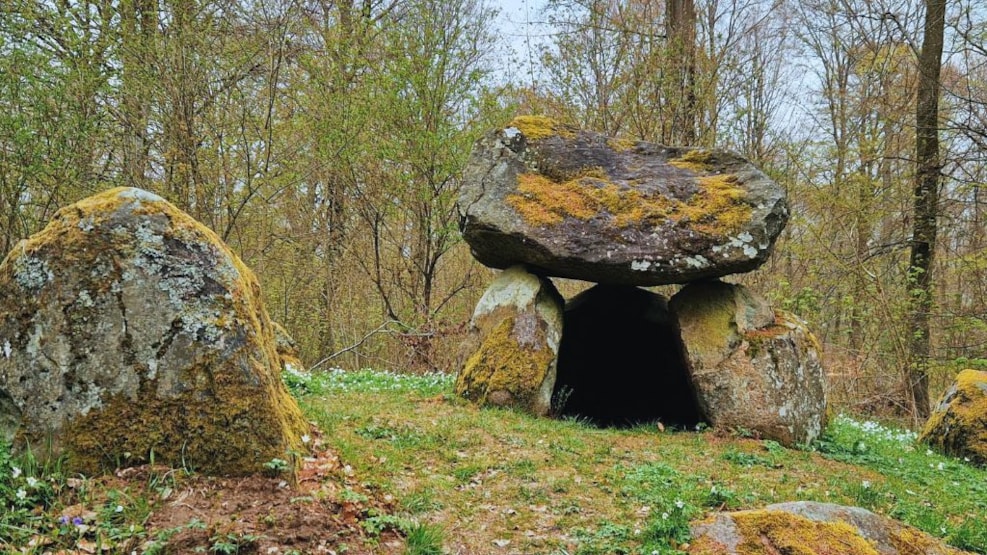
Long Barrows and Megaliths with Audioguide
In this part of Valby Enclosure, the experiences are lined up. On this route, you will pass seven long barrows from the Bronze Age 5500 years ago. At each point, you can get more information by calling an audioguide number.
The area around Tobro Å was most likely a waterway, so the megaliths are lined up like pearls on a string.
After the path makes a soft curve, look out for the sign to the long barrows on the right side.
Here you will find long barrows number 5 and 6 (audioguide phone number 99400876). Return to the route and continue on the path, then follow number 7 to the right (audioguide phone number 99400877).
Number 8 (audioguide phone number 99400878) lies beautifully at a crossroads, turn left. You will also pass number 16, which is just a raised area in the landscape and is not marked.
"The Nameless"
Turn right the first time it's possible. Where the road forks, you turn right. You will recognize the place by the road that goes to the left called "The Nameless".
You now come to number 9, which is the best-preserved (audioguide phone number 99400879). To the left, you pass number 10 (audioguide phone number +459940 0880).
Arrival at Helsinge Station
Continue straight ahead and you can glimpse Tobro Å on the right side. Where the road ends, you will see that it is called Tutteledsvej. Turn right and cross the parking lot. Turn left onto the asphalt road, which is called Bukkarvej (no sign). Now you can follow cycle route 703 to Helsinge station.
But the described route is as follows: Keep to the left to follow the signs over the main road on the pedestrian/cycle bridge. The path leads into Provstemarken. Turn right and immediately left onto cycle route 703, so you stay on the left side of the railway tracks. If you just want to go around the cosy pedestrian street in Helsinge, follow cycle route 702 instead. Turn right once more. After walking on the sidewalk of Kongensgavevej, turn right again, along the tracks. The path ends at Helsinge station.
Facts about the tour
- Surface: Forest paths, gravel paths, and very little asphalt.
- Length: The route is 13 km long.
- The tour is suitable for Children, adults, and dogs on a leash.
- Signage: You will encounter many different signs along the way; cycle route signs, health trails, and local signs, but use the map and tour description.
- Toilets: Helsinge station, Fuglebjerggaard (for guests), Charcoal Burner's hut, Græsted station.
- Weather conditions: In wet periods, the path from Hemmingstrupvej to the larger path in Valby Hegn may be slightly damp and uneven, as it also serves as a bridle path.
- Season: The tour can be done all year round.